
Dynamic Mapping and Collaboration
Premier GIS software and site planning tools for anyone who needs to understand land.
Latapult’s Easy-to-Use GIS Software Tools and Features

Nationwide Data
Instantly access datasets ranging from metro and state to nationwide from any computer or smart device.

Explore Data Layers
Explore GIS data layers including wetlands, elevation, HUB zone data, points of interest, census data, large parcel data, and more. Select attributes to search and receive a table of results.

Filter Data and Layers
Eliminate unfit opportunities to save time during land research and site selection by exploring datasets based on selected important criteria.

Proximity Search
Streamline site evaluation by searching for property with a certain distance of major roads or electric infrastructure.

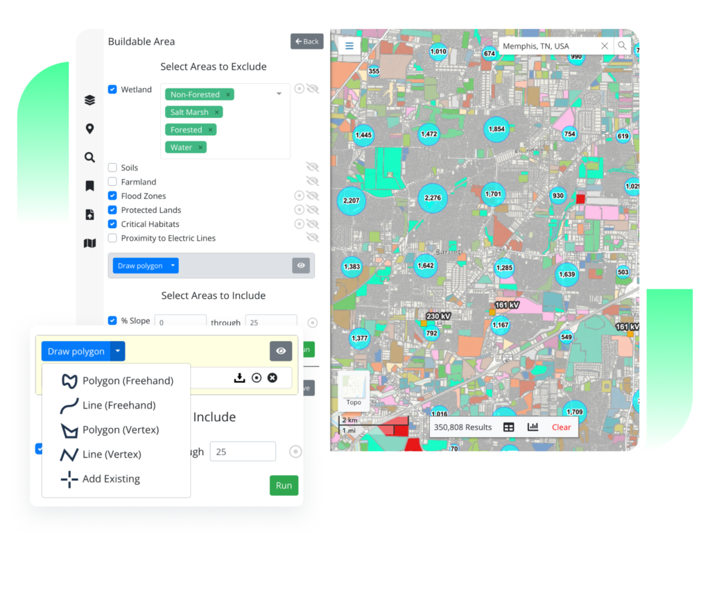
Buildable Area
Determine project feasibility and develop site plans by visualizing usable acreage for a property based on slope, wetlands, flood zones, and more.

Pins
Create and organize pins to track properties and manage the due diligence process. Collaborate seamlessly with team members no matter where they are located.

Bookmarks
Access, save work, create presentations, share information, and collaborate across your organization no matter where you are located. Draw your colleagues’ attention to what matters.

Related Properties
Quickly find related properties and simplify the parcel search process by mapping all property owned by a specific owner. All you need is the owner's name and address.

Customizable Maps
Visualize information for the biggest impact with PDF maps and graphics, plus pre-stylized layers for reports and presentations.

Graphics
Highlight areas of interest or visualize site layout with graphic tools—creating custom due diligence maps quickly and easily.

Travel Areas
View what’s in driving or walking distance from a property and compare potential site locations based on local amenities, plus see competitor activity.

Measure
Obtain lengths of a line segment, area of a polygon, or GPS coordinates of a point to learn the approximate size of an area.

Charts
Analyze sales trends with interactive charts to ensure you are always getting the best possible land deal. Quickly interact with data based on chart groupings.

Toolbar Functions
Gain a full understanding of the benefits and risks of your land projects with quick access to travel areas, graphics, and demographic reports based on census data, and more.

Number Parcels
Quickly identify desired parcels in a report with a single map of all properties with assigned numbers for easy reference.

Import and Customize
If you need to import attribute-level GIS data, level up your workflows with greater project tracking, or integrate with other systems like a CRM, you may need Latapult Custom.
Discover Latapult CustomLatapult's Training Center
Want to learn how to make the smartest land decisions for your organization? Our in-depth instructional videos and FAQs walk you through how to use our comprehensive data and seamless collaboration tools, plus demonstrate specific use cases for our GIS software features.

What our clients say about us
