
Latapult: GIS Software Built for Everyone!
August 2, 2023
From evaluating land based on specific criteria to the development phase of projects, land professionals like you are busy. You need technology that streamlines land evaluation processes, not software that makes it more complex and time-consuming because it is clunky or hard to understand. That’s why you need software that is simple and built to improve your due diligence workflows.
You need GIS software like Latapult.
Latapult was designed with the goal of making GIS technology accessible and easy to use for any and all industry professionals. GIS software has revolutionized the way we interact with data, making it easier than ever to explore, analyze, and visualize complex land information. What was before considered an industry reserved for experts, is now open to a wider audience, thanks to user-friendly GIS software and platform interfaces.
Below are Latapult’s key features that make land evaluation easier, and you feel like a GIS expert.
Understandable & Easy to Use Interface
Technology can be complex, but Latapult’s interface keeps things simple. When exploring mapping technology, users shouldn’t be required to have deep GIS knowledge to get the data they need. That’s why Latapult was designed with accessibility in mind. In fact, one data center customer said, “It’s lightweight and doesn’t require a ton of GIS programming or deep GIS knowledge like other systems out there.”
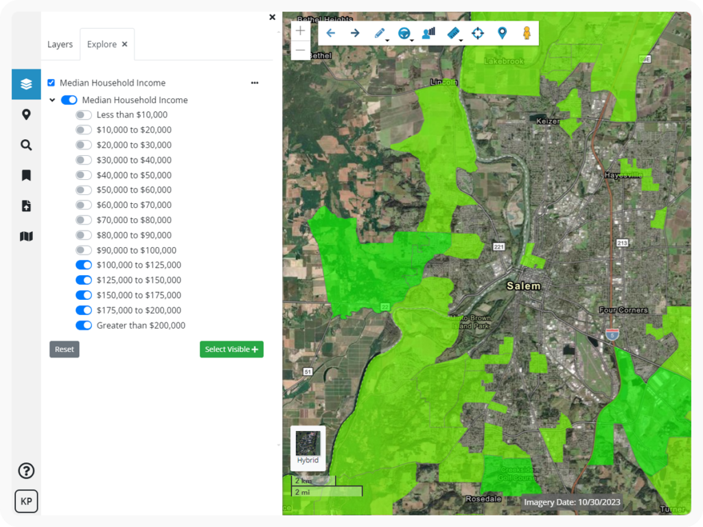
Single, Centralized Source of Data
Another thing Latapult aims to simplify is compiling data. Land Information has historically been hard to collect and analyze as it is frequently held in various, disparate, and often outdated sources. We knew there had to be a better way.
The Latapult platform contains hundreds of data layers collected from various local and national resources for users to access depending on project needs. With Latapult in hand, sifting through outdated resources or going to your local government agencies to collect data becomes a thing of the past. Latapult’s layers house all the necessary data in one place — saving land professionals time, money, and effort on their projects. Our customer, Sharon Foxworthy, Community Solar Developer at Empower Energies, recently said, “If I didn’t have this software I would be in a world of hurt. There is no way to get the amount of info as quickly as I can without Latapult.”
Fresh, Continuously Updated Data
Speaking of quality data, land professionals need accurate and up-to-date data in order to make effective project decisions. Latapult’s software is continuously updated with fresh data. In fact, depending on the data resource, Latapult’s data layers are often updated on a monthly, quarterly, or yearly basis to ensure customers have access to what they need. In fact, Hillary Shipley, Principal at Colliers International, told us, “We’re in a business that’s constantly moving, so I need fast access to land data multiple times a day.”
Bonus: We’re always looking for ways to add more data to our platform like the solar energy community dataset we added when new tax credit opportunities became available.
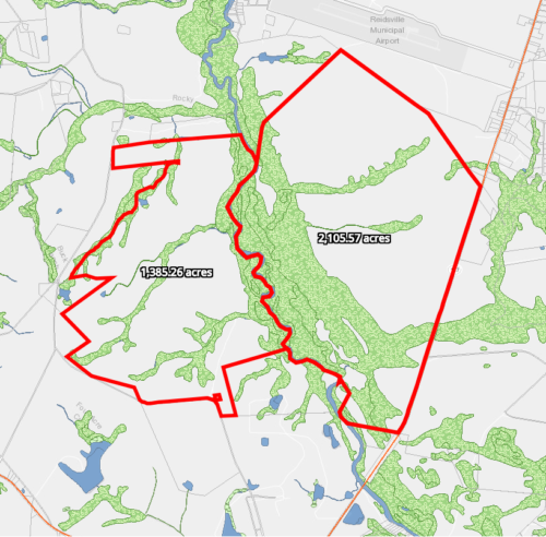
Presentation-Ready Visuals
Whether you’re looking to acquire land for a solar project or assess site quality for a commercial acquisition, there’s a lot on your plate as-is. To prevent users from needing to take additional time to create visuals from the data within Latapult, the software displays land information that’s presentation-ready.
Tools for Effortless Collaboration Across Teams
Communication is key to success. If different departments or project teams aren’t able to access and view the same data, decisions may be slowed or opportunities missed. With Latapult’s various tools and features, teams can cross-collaborate right within the platform whether it’s bookmarking data, adding project notes, or including information attachments. A land development customer mentioned, “I can save bookmarks of concept site plans with graphics to collaborate with my partner.”
I can save bookmarks of concept site plans with graphics to collaborate with my partner.
Scalable, Cost-Effective Solutions for Different Teams’ Needs
From solar developers to commercial real estate professionals, Latapult serves many different industries with teams of all sizes that have various land needs. Latapult offers scalable packages with different features and data availability at price points designed to meet the needs of any team. Whether you’re a one-person shop needing local land data or a large team looking for data that spans the entire United States, Latapult’s platform is scalable to you. In fact, a land development customer once said, “It’s nice we don’t have to pay for a huge data set if we don’t need it. We value Latapult and it’s not more than we need.”
Continued Learning Opportunities to Empower Users
We want to make GIS accessible, but we also want to encourage a deeper understanding, so users are comfortable and get the most out of the platform. With a user-friendly interface, and easy-to-understand data layers and tools, the Latapult platform can make any and all industry professionals feel like GIS experts. We do this by providing various educational resources about GIS, such as our blogs, Tune-Up Tuesday videos, and more! With multiple ways to keep learning, our customers always stay informed like Mike Hughes, Senior Project Manager at Thomas & Hutton, said, “Because it’s so easy to get answers, Latapult empowers us to ask more questions, and by asking more questions, we – and our clients – are able to make smarter, more profitable, faster decisions.”
Outstanding Customer Support
Lastly, the Latapult team is always here to answer questions and guide customers through the learning process. We are passionate about GIS and helping customers make the most out of the platform. Shoutout to Sharon Foxworthy, Community Solar Developer at Empower Energies, who gave us this compliment, “Everyone is very responsive. Great customer service!”
Everyone is very responsive. Great customer service!
Latapult’s user-friendly interface, quality data layers, and helpful tools can empower all industry professionals to feel like GIS experts.
Sign up for a free demo to see how we can support you in your industry!


