
Premier GIS Mapping Software
geothinQ Is Now Latapult
We have a new name and look, but our dynamic mapping, collaboration tools, and deep GIS expertise haven’t gone anywhere.
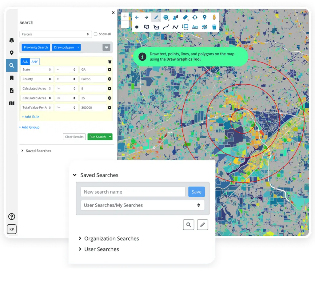

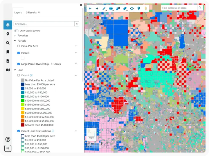
Comprehensive Land Data
Access millions of dollars worth of regularly updated GIS data, powering environmental, demographic, geospatial, and topographic insights.

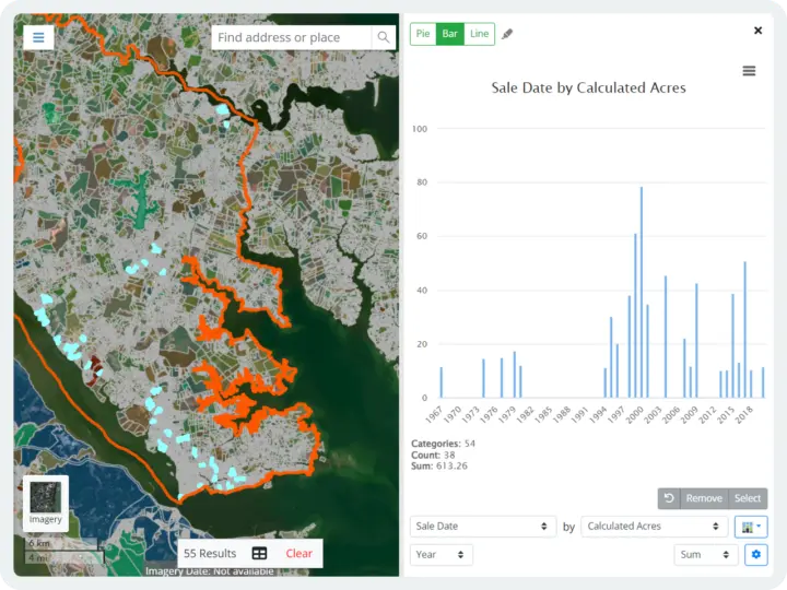
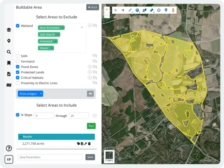
Location-Smart Decisions
Simplify complex data to confidently problem-solve and make focused business decisions.

Seamless Collaboration
Combine dynamic GIS mapping with your industry expertise to easily track projects and site status, plus share plans and information with stakeholders.

Trusted Partnership
Get personalized support from our in-house geospatial experts when you need it.

Always Evolving
Have geospatial experts in your corner constantly improving, refining, and expanding how you can apply GIS and use maps to understand land.

Versatile and Accessible
Use our GIS software anytime, anywhere. If you have access to the internet, you have access to Latapult.
Solutions for How You Work
Dynamic mapping and collaboration tools that change the game for anyone who needs to understand land
Land Evaluation
Validate business strategy with comprehensive land data and intelligence. Bring the most comprehensive GIS data and insights to your team.
Land Acquisition
Select sites that will attract investor attention and generate returns. Partner with us for land searches, suitability analysis, and site planning.
Land Development
Plan, prepare, and execute on site projects by starting with a strong understanding of your location. Share knowledge with distributed teams.
What Our Clients Say About Us

We amplify your industry experience with geospatial expertise.
From our roots in geospatial data analysis, our team of GIS developers and analysts is constantly improving, refining, and expanding how you can use maps to make decisions. We are a trusted partner, helping professionals across industries complete successful projects through collaborative tools and deep insights. We are GIS experts so you don’t have to be.

Our GIS software can be customized.
We understand that sometimes organizations benefit from a tailor-made platform. Whether they need to import attribute-level data, improve workflows with deeper project tracking, or integrate with other systems like a CRM, our team of geospatial experts work with clients to customize our software. We love helping clients take our data and collaboration tools to the next level to solve their unique challenges.

Put your trust in experienced hands.
-
300+
Businesses nationwide
Supported in uncovering insights that transform projects.
-
50x
Faster land research
To justify, approve, and negotiate land deals quickly and strategically.
-
$1K+
In savings a month
Per user on resources, labor, and more.
-
$1M+
In GIS data
Powering environmental, demographic, geospatial, and topographic insights.
Launch your land intelligence.
Metros
$149/mo
+$49 for additional metros.
Explore properties in a growing metropolitan area across the country. Best for honing in on specific areas.
States
$299/mo
+$199 for additional states
Research land across a state while gaining energy layers and large parcel ownership data (5+ acres layer). Best for searching statewide.
USA
$999/mo
Discover nationwide insights while gaining unlimited access to all our comprehensive data and mapping tools. Best for searching without regional limitations.


3 Steps to Streamlining Your Real Estate Workflow with GIS

How GIS Technology Saves Time and Money During Site Selection

4 Ways Technology Can Help Your Buyers Evaluate Commercial Real Estate Investments

geothinQ Is Now Latapult
5 Ways GIS is Changing the Game for Real Estate Professionals

GIS Technology for Every Step of Your AEC Project
